Showing posts with label Urban Planning. Show all posts

Saturday, December 07, 2013

Let's go to Beverly Hills!


About a week ago I had a super quick trip to Beverly Hills. There was a position that was open and I was invited to sit for the exam, so I took the day off and went down to throw my name in the hat. I had less than 24 hours there, but the trip ended up being good: I had a chance to reconnect with some friends and take a quick look around the famed Beverly Hills. 

My first memory of hearing about Beverly Hills comes TV, but not from what you're probably thinking of. I never saw Beverly Hillbillies and 90210 wasn't it either. The very first time I remember "Beverly Hills" being mentioned was this monstrosity:


Beverly Hills Teens. "Come live your fantasy in Beverly Hills. Come on and make your dreams come true..." Somewhere between Transformers, Teenage Mutant Ninja Turtles, and Inspector Gadget there was this. The 1980s were something else and there was so many cartoons floating around. If you watch the intros to the cartoons that played on Saturday morning, I bet you'll recognize some that you've long forgotten.

But, on this trip I had a chance to take a look around the actual city of Beverly Hills. The city was established in 1914 and exhibits a rather beautiful design that takes advantage of the natural features of the area. The story is that after some oil prospectors failed to find any oil in the area, they decided to try to set up their very own city. The city was laid out by Wilbur D. Cook who was heavily influenced by the Olmsted Brothers and reflects an approach to planning called "City Beautiful". This was a movement that preferred organic shapes, placed emphasis on civic pride and monumentalism, and the need for nature near to where people lived. It was a softening of the geometric grids and the idea that cities could be better places than they were. It's a goal is still central to urban planning today, even if the terminology and ideas about how to get there have sometimes changed.

A lot of the places that we really like today came from this era and Beverly Hills is actually pretty nice. The streets north of Santa Monica Blvd curve elegantly without completely losing the efficiency that a grid system offers. The houses are mostly upscale and become nicer as you move into the actual hills. The city leaders built a very nice civic complex, starting with the city hall below. With about 35,000 people and a more geometric downtown core, it seems like they have actually done a good job at managing their growth over the past 100 years (which you can see in the image to the left). 
Of course, as beautiful as it is, with only 24 hours there's not much time to do anything... except perhaps to try some cupcakes!


Tuesday, August 13, 2013

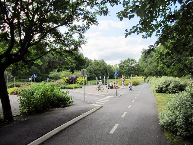
Traffic Education in Näsby Park - Trafiklekparken

As an urban planner, I'm always looking for good ideas to steal and bring back home. One of the best thing about travel is that there is such a diversity of ideas about what is "good" and what will work out in the built environment. There is just more opportunity to run into something novel, and that's exactly what happened to me out in Näsby Park (a suburb of Stockholm).


One of the big problems that we have in urban environments is teaching children how to cope with a downright dangerous and usually unfriendly environment for children. Traffic and kids are not a natural combination and one error, on the part of the driver or the kid, can turn a fun walk to a friend's house into a nightmare headline. Educating kids about traffic safety is absolutely vital to a healthy community. By giving kids the age-appropriate tools they need to independently navigate their own community, we give them additional independence and prevent needless accidents. Unfortunately, all to often the places where kids get their education about traffic safety is on their local streets. In the United States, there is seldom a place where kids can practice the skills they need to be safe on their way to school or to a friend's house outside of the street itself. But, what would it look like if there was a safe place for kids to learn to read the traffic signs and symbols of the street without having to be in traffic?

Well, we don't have to wonder. The trafiklekparken (Traffic Play Park) provides exactly this type of environment for children to play, learn, and not have to learn from close calls.


The park itself is located in a larger park and was built in 2007. The park provides children with a miniature traffic world, complete with accurate (if miniature) signs, a variety of different types of intersections (including a roundabout), marked sidewalks, a pretend bus stop, and a railroad crossing (complete with movable booms). It includes 20 different signs and asphalt markings that are crucial to traffic safety. With a parent in tow, this presents an ideal environment for learning about traffic safety. Even without the overarching pedagogical content, the kids here looked like they were having a blast biking around the roads.

Is this something that you want in your community? Share this with your neighbors, local bike advocates, and the parks department for your city! It's an idea worth stealing!

You can find out more information about the park (in Swedish) here: http://www.taby.se/Stadsbyggnad_trafik/Parker-och-natur/Barn-och-unga/Lekplatser/Trafiklekplatsen/
There is also a PDF brochure about the park here: http://www.taby.se/PageFiles/6040/Broschyr_webb.pdf


Friday, October 19, 2012

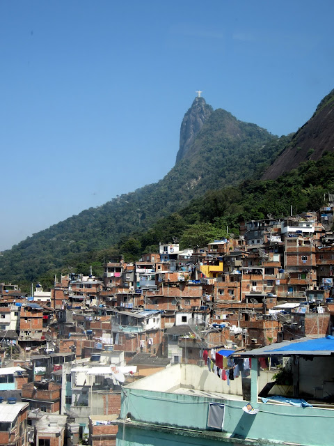
The Other Side of Rio: Favela Santa Marta

Rio is a fantastic place, but the city is not all glitz and glamor. One of the things that becomes distinctly obvious when you are in the city is that the city is really several cities on top of each other that are interwoven, but separated by money and class. Just as synonymous with Rio as Ipanema, the Favela is also part of the city and its identity.

 A favela is what is often inelegantly called a "shanty town", but from an urban planner perspective these area are informal settlements. They are part of the built environment that were built without architects, planners, or engineers and instead with the materials on hand and expertise developed through experience. They are also notable because favelas are usually located on hillsides that the formal city ignored. While I was in Rio, I wanted to visit Santa Marta, which is a favela that I studied while in Sweden as part of a human settlements and housing course. From Scandinavia, I had already studied the maps, structures, and satellite images of the area, along with news papers and research on Santa Marta and the socioeconomic issues involved. I wrote a paper on the place, but I had never been there. This was a chance to see it for myself and touch what I studied.


There are some issues involved with visiting a favela. The first and foremost is whether you should visit one at all. Favelas exist because of economic inequality and as a foreign tourist, you stand on the privileged side. In many ways the economic disparity that causes favelas to exist is also the reason you are able to enjoy Rio to the extent that you do. Your hotel room in Rio for a single night is likely more than half a month of rent in a favela (which is between $75-$250 a month, according to here). When you visit a favela, you are seeing a side of Rio that is foreign to you. It is another city and although some favelas (such as Santa Marta) are becoming safe enough to visit independently, your presence in this tight knit community is almost a transgression. The streets and stairs in the favela were built by the the people who live there, not by the government, and you are using them. It would be easy to come into the community as a poverty tourist, someone who engages the community as an exploitative voyeur. Many of the tourist that now visit favelas are likely motivated either by a romanticism of poverty, a sense of curiosity similar to when you visit a zoo, or in the worst of cases, a desire expressed or unexpressed to experience schadenfreude upon seeing the "others". Our intent was none of these, and we hope that our intentions were understood through our actions and respect for the place. 


On other side of this question, is it right to simply ignore these places and the social division in Rio? Rio de Janeiro is a city of contrasts and experiencing the community and place of a favela is a way to gain balance in your perspective. It is also a way to balance the image of favelas, portrayed in the news and media, with the realities of the favela. By being there, you can gain a better understanding about what is true and what is drama. This is something that can have value if it is done right. In our case, we hired a local guide named Gilson Fumaça because we felt that the jeep tours didn't give us enough assurance that what we paid would go directly to the community. He is from the favela and works there when he doesn't have a tour going on. He is part of the Rio Top Tour program, which helps train favela residents to offer their own tours of the favela without having to go through a middle man. Even though there was a language (helped dramatically by another guide that decided to join us/took pity on us), one that that Gilson was able to do was to make us more accepted within the community. As we walked, it became clear that he knows the community and is on good terms with seemingly everyone. He would great an old lady who would go from at first wary of us to smiles, after a few words and a smile from our guide. After the tour, both of us (I was there with my other planner friend) felt that even though we weren't able to ask as many questions as we would have liked due to us not speaking Portuguese, having Gilson show us around was the right way to visit. Today, after visiting, I would say that this favela, Santa Marta, is safe enough to visit independently, but I remember seeing some other unguided tourists and it was clear that they were not really welcome from the looks they were getting. Tourism in the favela is still a debate.

After the break, many more pictures from the favela and my observations of the favela and what it means for the city.

Tuesday, August 21, 2012

Biking the Greenways of Portland

Portland has a reputation that precedes it and much of it centers on the bicycle culture that has sprung up in the city. On my last trip there, I left my car in Seattle, hopped on BoltBus, borrowed a bike (Thanks Alexa!), and put that reputation to the test along with a group of about 30 other community advocates from the Seattle area. We were all there on a study trip to learn more about the neighborhood greenways ("Next Generation Bike Boulevards") that have started to crisscross the neighborhoods.

If you've never heard of a neighborhood greenway, the basic idea is to create a neighborhood street that brings back the type of activities that have disappeared because of cars having absolute priority on all streets. On a neighborhood greenway, priority is given to pedestrians, bikes, and neighbors instead of cars. The basic formula is relatively simple:
  1. You start with a residential street that already has a low traffic volume.
  2. You add improvements to the street that keeps residential traffic at residential speeds andlets bicycles move along the street without having to stop every block or two. 
  3. You make the streetscape more appealing for those who live along the path.
  4. You add cost effective improvements at major arterial crossings to create a safe place to cross busy streets.
The end result is a street where people of all ages and abilities can get on their bike, perhaps for the first time or perhaps the first time in years, and feel safe. The roads remain open to cars but because of the changes, cars move slower, more safely, and make less noise. These have been highlighted as success stories in Portland and we wanted to see what it was all about. 

After the break, a look at neighborhood greenways, as well as a couple photos from Pine State Biscuits (a great brunch place) and Salt and Straw (a tasty ice cream shop right nearby).

Friday, April 27, 2012

Walking in LA: Eating in Echo Park and Silver Lake

My favorite part of LA is, without a doubt the area between Los Feliz and Echo Park. Los Feliz and Silver Lake are both very nice neighborhoods and Echo Park has recently become a trendy place to be. For me, Echo Park has always been home as long as I can remember (The Pioneer Market? I remember playing Teenage Mutant Ninja Turtles there as a kid). Being back was a great chance to take a walk around the neighborhood and check out what's changed.

Of course, I love restaurants and things have changed quite a bit there. The area at Sunset and Hyperion in particular is now full of interesting places to eat and check out. Intelligentsia is now in the area serving up great coffee that often attracts a line and new restaurants link Berlin Currywurst and Forage are popping up next to traditional places like Millie's Cafe and Madame Matisse. In this post, we'll visit a couple neighborhood places and check out a very cool urban intervention when I put my planner hat on.

Want to find out where to get this?

Or this?
Or see this?

If so, keep reading after the break! We'll check all of these places out.

Tuesday, February 28, 2012

Walking Downtown Bainbridge Island (and Taking a Look at Their New Complete Street)

A couple of weeks ago, I wrote about the ferry to Bainbridge Island, which is of the best mini-day trips that you can do from Seattle without a car. While I covered the trip itself, I didn't talk about what to expect on the other side. I'm going to correct that right now. Bainbridge Island’s downtown is an easy visit and very walkable. Virtually all of the restaurants and shops are within 15 minutes from the ferry at a casual pace and if you take your time to browse all of the shops and have lunch, Bainbridge Island will give you a solid afternoon retreat from Seattle. It's a great place to explore yourself, but in this post I'll share a few of my favorite places downtown.


The ferry itself can carry cars, but bringing a car along doesn't add anything unless you intend to continue on to the Olympic Penninsula. Instead, just walk to the ferry terminal and then on to the boat. It's $7.50 for an adult and $6.05 for kids 6-18, but you only pay westbound. The return trip from Bainbridge Island is free on foot (although if you drive, you pay to come back as well). Once you're off the boat, there are two options to get downtown, the first is along the main street and the second is a more scenic route that goes by the water. When you're walking up towards Winslow Way, look for the waterfront trail sign if you'd like to take the scenic path.


There are a couple of spots that stand out and are personal favorites here, as well as a place or two that I decided to try this time. I took the opportunity to try Hitchcock’s Delicatessen, which opened adjacent to their established dinner restaurant in the final months of 2011 and Mora Iced Creamery, which has been offering flavors influenced by the tastes of the Argentinian owners since 2006. In addition, I also visited three of my favorite local spots: Blackbird Bakery, Pegasus Coffee, and the Harbor Public House. Stay tuned and after the break we'll take a photo tour of the area.

Plus, at the very end, we'll even talk a little planner shop about the new "complete street" improvements that were recently completed on Winslow Way to make it more pedestrian friendly (If you're feeling impatient, you can jump to that discussion by clicking here).

Sunday, October 23, 2011

Goodbye Viaduct

This last Saturday, WSDOT opened up the viaduct for one last hurrah before shutting it down for the first part of demolition. Between the hours of 9:30 and 12:30, anyone could come down and walk up and on the viaduct and being a bit of a transit nut, I decided to go down and look at the structure from a new perspective (as well as claim my chunk of the viaduct). It was an appropriately wet Seattle day, but even with that over 3,000 people turned out to say goodbye.


The viaduct may be an ugly, 1950 concrete wall on the Seattle waterfront, but what everyone came out for is this: The view. On a nice day, driving on the viaduct is the best introduction you can give a person to Seattle. On the right, a close up of the city and on the left the ferries, Olympic mountains, and the Sound. In terms of a comprehensive, easy to access, and beautiful scenic drive this is about is good as you can get in the city itself.

After the break, more photos from the event, including the people, their goodbye notes, and the structure itself.

Thursday, May 05, 2011

Abu Dhabi: The Autopia Captial of the UAE

Ford Prefect: Didn't you think it was strange I was trying to shake hands with a car? 
Arthur Dent: I assumed you were drunk. 
Ford Prefect: I thought cars were the dominant lifeform. I was trying to introduce myself.
-From The Hitchhiker's Guide to the Galaxy

A few weeks ago I wrote about Amsterdam and how transportation choices hundreds of years ago shaped the city that we know today. When it comes to transportation there is no technically "right" answer, but the transportation choices that we decide upon have distinct trade-offs. Abu Dhabi is an example of a city that is heavily invested in the automobile. Ford, an alien in The Hitchhiker's Guide to the Galaxy, mistook for our cars for local sentient species on earth. During the day in Abu Dhabi, it would be easy to make the same mistake. 


What you see here is shot from Google Maps and each of those white dots is a car. Two eight lane roads (four lanes in each direction) meet and define the super-block within which we more cars sitting in wait. Most of the inner city is like this, although there are parks and open space elsewhere, especially along the waterfront.

In the area that I was staying in, this was the scene. The traffic in Abu Dhabi, a city of about a million people, does flow smoothly, but this is the cost: Every major street is at least four lanes wide and here we have two seven lane one-way roads to move traffic. Driving is stressful, but at the end of the day traffic does move. Outside of downtown, traffic is less hectic than here, but in Abu Dhabi one thing is for sure: The car is the king.

More urban pictures and transit talk after the break...

Friday, April 01, 2011

Amsterdam: Good (17th Century) Urban Planning


It's said that we shape buildings, but thereafter they shape us. Nothing could be more true. Buildings are a reflection of the values and social structures of the period when they are build, and are designed to enable (and reinforce) the social norms of the time. When a particular building style or convention takes off, it literally does reshape the social interactions that are possible within that space. Similarly, we also shape cities, but thereafter they shape the lives of all residents within the city. So far, Amsterdam is the best example of this that I've found.

The canals of Amsterdam are the result of urban planners of the 17th century grappling with the challenge of how to facilitate seemingly endless trade in the city of Amsterdam during the dutch golden age. Being a low country, any canal dug will fill with water easily and this was used to put virtually every building in old Amsterdam within walking distance of a point where boats could bring goods in and out. The steam engine didn't exist, which meant that all serious trade happened by way of the water. Building canals was like building superhighways: it made trade and travel cheap and easy inside of Holland. It was a practical solution for the time, but today it's more seen as charming than functional.

The choice to build extensive canals gave us Amsterdam today. The signature buildings that we find today along the canal where built with hoists to offload cargo from boats and designed with large loft spaces for craft and business (as well as living quarters). Today new shops shoehorn themselves into these tiny but functional spaces, using space vertically instead of horizontally to fit the new function into the old form. Investing in water traffic also meant a practical limitation on how much ground transport the city could support which has made cars relatively rare in the center of the city. Of course, it's not that the Dutch dislike cars, but the center of the city doesn't cater to them and the thought of trading a canal for a street is unthinkable today.

But what else is there in Amsterdam? More photos of Amsterdam, Tulips, and late night local street food after the break!